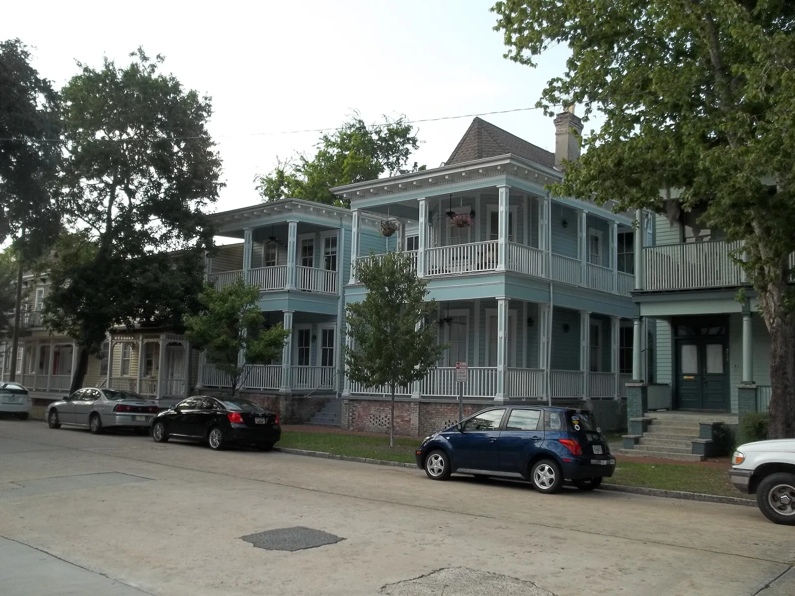
Savannah's Victorian District, beside Forsyth Park, is ZIP 31401; 86% of its homes predate 1940. Zillow's typical value was $556,330 in August 2026.
Last checked Oct. 6, 2026. Sources: the City of Savannah’s neighborhood boundaries and neighborhood association list on SAGIS, the school system’s address lookup, the state’s 2025 School Grades data, Chatham County’s 2025 parcel digest, Zillow Research, Chatham Area Transit and OpenStreetMap.
The Victorian District is the band of houses built around 1900 just south of the squares, on either side of Forsyth Park. The city’s neighborhood map splits it in two, the West Victorian District and the East Victorian District, and together they cover about 0.18 square miles. Seven in 10 of its parcels are homes in the county’s records.
What this means for you
- Zoned high school: Beach High west of Bull Street; the School of Liberal Studies at Savannah High east of it. Check an address in the district’s lookup.
- Home value: $556,330 in ZIP 31401 in August 2026, according to the Zillow Home Value Index.
- Nearest interstate exit: I-16 exit 167A, Martin Luther King Jr. Boulevard and Montgomery Street.
Part of our Savannah neighborhoods guide.
Where it is
The area runs from Gwinnett Street south to Anderson Street, from Martin Luther King Jr. Boulevard on the west toward Habersham Street on the east, with Forsyth Park between the two halves. The streets with the most addresses in the county’s 2025 parcel records are Duffy Street, Park Avenue, Waldburg Street, Bolton Street and Henry Street; Abercorn, Whitaker, Barnard, Drayton and Montgomery streets cross them.
- ZIP code: 31401.
- Inside city limits: yes; the city provides police, fire and trash service.
- Neighborhood associations: the city’s list names the Victorian Neighborhoods Association for both halves, and the Forsyth Park Community Alliance for an area that takes in the park, the east side and Dixon Park.
Homes
The county’s 2025 parcel digest lists 736 parcels here, 510 of them residential.
- 86% of the residential parcels were built before 1940.
- Half list a year built of 1900 or earlier.
- 12% date from 2000 or later.
Schools
We ran 80 homes chosen at random from the county’s parcel records through the school system’s address lookup on Oct. 6. Scores are 2025 College and Career Ready Performance Index (CCRPI) figures from the state’s School Grades report.
| Level | School | Share of homes | 2025 CCRPI |
|---|---|---|---|
| High | Beach High (report card) | 60% | 67.8 |
| High | School of Liberal Studies at Savannah High (report card) | 40% | 53.9 |
| Middle | DeRenne Middle (report card) | 60% | 57.2 |
| Middle | Hubert Middle (report card) | 40% | 52.1 |
| Elementary | Gadsden Elementary (report card) | 60% | 68.9 |
| Elementary | Andrea B. Williams Elementary (report card) | 40% | 64.8 |
The line is roughly Bull Street. Almost every sampled home west of Bull went to Beach, DeRenne and Gadsden; homes on the east side went to the School of Liberal Studies, Hubert and Andrea B. Williams, with the Henderson E. Formey Early Learning Center for the youngest grades. More in our schools guide.
Home values
The typical home value in ZIP 31401 was $556,330 in August 2026, down 3.30% from $575,317 in August 2025, according to the Zillow Home Value Index. The index is a modeled typical value for the middle third of homes, not a sale price, and the ZIP code also covers the Historic District and Thomas Square. The citywide figure was $322,239, down 2.82%. More in our home prices guide.
Parks
- Forsyth Park, 621 Drayton St., sits between the two halves of the district. The SAGIS parks layer puts the park itself in the South Historic District.
More in our parks and trails guide.
Getting around
- Interstate: I-16 exit 167A, signed for Martin Luther King Jr. Boulevard and Montgomery Street in OpenStreetMap, is about 0.6 miles from the middle of the district in a straight line. Exit 165, for 37th Street, is about 1.1 miles.
- City Hall: about 1.4 miles by road to 2 E. Bay St.
- Airport: about 12 miles by road to the Savannah/Hilton Head International Airport terminal. Both are distances on the OpenStreetMap road network, measured with the OSRM routing engine, not drive times.
- CAT buses: routes 4, 11, 12, 14, 17, 25, 28 and 31 stop in or next to the district, according to Chatham Area Transit’s stop data. Times are on CAT’s schedules page.
Groceries and everyday stores
From OpenStreetMap:
- Kroger, 311 E. Gwinnett St., inside the area
- CVS Pharmacy, 119 Bull St., about 0.8 miles north in the Historic District
How we drew this area
The edges are the City of Savannah’s boundaries for its East and West Victorian District neighborhoods, from the layer its Development Services Department keeps on SAGIS. School shares come from 80 randomly chosen homes run through the district’s lookup on Oct. 6, 2026; the lookup and the school system decide any one address. Home counts and years built are from the county’s 2025 parcel digest. Store locations are © OpenStreetMap contributors.
Frequently asked questions
Is the Victorian District a good place to live in Savannah?
Here are the facts. It is the city’s East and West Victorian District neighborhoods, between Gwinnett and Anderson streets beside Forsyth Park, all in ZIP 31401. West of Bull Street, homes are zoned for Beach High (2025 CCRPI 67.8); east of it, for the School of Liberal Studies (53.9). Zillow put the typical value in 31401 at $556,330 in August 2026.
What high school is the Victorian District in Savannah zoned for?
It depends on the side of Bull Street. In the district’s address lookup on Oct. 6, 2026, almost all homes on the west side were zoned for Beach High and homes on the east side for the School of Liberal Studies at Savannah High.
How old are the houses in Savannah’s Victorian District?
In Chatham County’s 2025 parcel records, 86% of the residential parcels were built before 1940, and half list a year built of 1900 or earlier.
Is there a grocery store in the Victorian District?
Yes. OpenStreetMap places the Kroger at 311 E. Gwinnett St. inside the area.
Have your say